Location: Harpers Ferry is a historic town situated at the confluence of the Potomac and Shenandoah rivers. Maryland, West Virginia, and Virginia all meet in this town. Three states in one run! The town has history in American industry and the Civil War. Additionally, the Appalachian Trail passes within feet of the town, and the Appalachian Trail Conservancy headquarters is there.
 |
| Shuttle bus from the visitors center. |
Route: There are multiple trails radiating from the Lower Town District. I chose the Maryland Heights Trail, one of the longest and most demanding trails. There are two loops consisting of roughly 7 miles. To reach the trail head, you start at the visitors center run about a mile, traveling a bridge across the Potomac River and a flat trail along the river. The elevation range is from roughly 230 ft to 1450 ft above sea level. Quite a hike up considering much of that is loaded into about 2 miles, and similar on the down side. The terrain of the trail itself is a mix of small stone/dirt and large rocks. I would say about 50/50.
 |
| The Mighty Potomac |
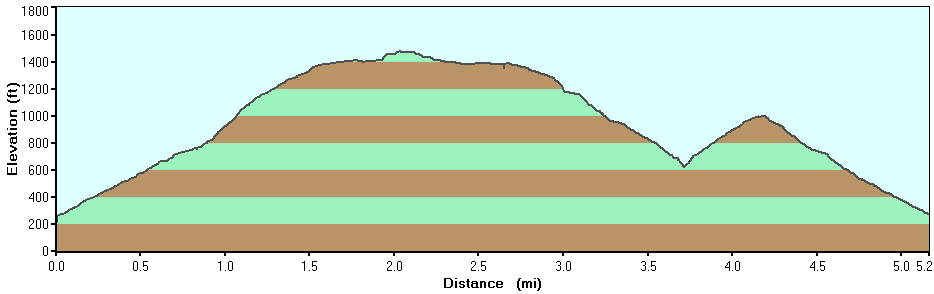 |
| Pretty steep elevation, huh? |
The Experience: I had the weekend to myself. Jen and the kids went to the beach with her aunt and family while I stayed home with the doggies. We have a newly adopted Boston Terrier, that was rescued from a puppy mill, and we didn't think it was a good idea to send her to a sitters just yet. I spent most of Saturday working in the garden and/or relaxing.
 |
| Train tunnel through the mountain. |
Sunday was a beautiful day. The weather was in the 80's and only partly cloudy. The drive to Harpers Ferry took about 1.25 hours. Upon arrival, I had to take a shuttle bus from the visitors center down to the Lower Town District, It's small but quaint and picturesque. I took no time hitting the trail though. Running along the road from the shuttle drop-off, I passed quickly between Virginia and into West Virginia, then crossed the bridge over the Potomac into Maryland. After this is was a quick run along the river to the trail head, or it should have been. I missed the sign for it and kept going. After a good 1/4 mile or so, I started thinking that I'd missed something. Scrambling to read the trail map, I realized my mistake and headed back.
 |
| Looking up at "Overlook Cliff" It's hard to see, but there are rock climbers dangling from the top. |
 |
| Chillin' in the river. I so wanted to do this at the end, but nothing to change into. |
Finally, there it was, and I was heading up. The climb was steep and immediately I was feeling it. The path was approximately 6-8 feet wide and good sized gravel rocks. After what seemed like 20 minutes, I made it to the fork in the trail that gave me two paths. 1) I could continue straight and head to The Overlook Cliff or 2) I could make a left and head to the Stone Fort. I examined the map and based on the elevation markings, I opted to head to the Stone Fort first. Good choice. It was a tough 1.5 miles or so with a steep incline, but I eventually made it and was rewarded with some great views.
 |
| It started like this... |
 |
| ...and quickly became this. |
 |
| The view from one of the summits. |
I met a couple at the top that were also trail running. We talked a good few minutes about running and some of the ultras they've done. They were interested in the Golden Gate Trail Marathon as well. Then we headed downhill towards the overlook. This is where the terrain got very rocky. I stayed fairly close to the couple and eventually we made it to the fork and headed down to the Overlook Cliff. This was a gorgeous view of the town with both rivers. Very nice!!
 |
| Looking down from "Overlook Cliff", this was above the rock climbers. |
 |
| Cool rock formations to the right of the cliff. |
 |
| Refreshed and ready for the last leg down. About 2 miles down to the area behind my head. |
I stayed awhile longer than the couple did, had some almond butter, and prepared for my last ascent. I didn't have a long way to go back up, but it was rocky and demanding. Soon, I was done with climbing and it was all downhill from there. Steep, rocky, quick downhill all the way back to the road. I was doing great until that point. I hit the flat road, in the sunlight, and fatigue slapped me in the face. I made the trek back across the bridge to town and was done. Tire, hot, and thirsty.
 |
| The end is in sight! heading back across the Potomac and to the end. |
I still had water in my pack, but I was lusting for something iced, and some food. The town had several restaurants, so I checked them out and settled on one where I got a large ice water and a hummus, tomato, basil, lettuce, and feta cheese burger with coleslaw and French fries. It was deliciously satisfying after such a demanding trail. After downing the food, I grabbed the shuttle back and headed for home, tired, but satisfied.
 |
| Hummus, tomato, lettuce, feta, and basil. YUM! |


2 comments:
You had a cheeseburger!?!?!?!?
feta cheese, on a hummus burger. No meat!
Post a Comment