Brace yourself, this is a long one!!
This race report really begins on July 4th, when we left Maryland for a vacation in California. I won’t go into tons of detail leading up to the race so here is a basic synopsis of the trip.
July 4th – Travel Day. We got in that afternoon and chilled at the hotel
July 5th – SeaWorld – A long day of aquatic antics and marine mischief
July 6th – La Jolla, Old Town San Diego, Seaport Village
July 7th – Balboa Park (only pre-race run), Old Town again, Travel to Los Angeles
July 8th – Hollywood, Santa Monica
July 9th – Disneyland – A very long day of Mickey Mania and Thrill rides
July 10th – Family Meet up (Parents, Sister, and Niece traveled with us the rest of the trip) in Santa Barbara and travel to San Simeon
July 11th – Travel the coast to San Francisco
July 12th – Fisherman’s Warf, Alcatraz, and Golden Gate Bridge
July 13th – Golden Gate Park, Haight-Ashbury District, Hotel (I had some pain, more on that below)
July 14th – Race day, travel home
July 15th – home to recover
If you noticed, I only got one run in before the race. I had a nice 3 miler through Balboa Park. I was a photo taking fool too. People must have thought I was nuts.
Ok, now it’s time to get into the nitty-gritty. Everything was going great until I woke up on the 13th. I notice some stiffness and pain on my left foot. It was that tender area between the Achilles Tendon and your ankle bone. I don’t recall anything specific that might have triggered it, but with all the walking the last week, it could have been anything. I didn’t give it much thought until around lunch when it just wouldn’t go away, therefore, I decided to sit the rest of the day out at the hotel. Needless to say, I was worried about the race, if I should run it or not, and I was pretty depressed. I decided that if I didn’t at least try, I would regret it, so I decided that if it didn’t feel worse, I’d run. Thankfully I did and it didn’t. Before bed that night, I packed everything up (I wouldn’t be coming back to the hotel), and paid out my running gear.
I woke up Saturday morning and my immediate thought was that I could still feel some stiffness. I changed clothes, wrapped my ankle with an ACE bandage, and met Jen down stairs for breakfast… eggs, English muffins with butter and jelly, orange juice and an apple. After that, we hit the road. It was a 30 minute drive up, but there was an accident which caused us to detour through the city. I think we made it in about 40-45 minutes, still plenty of time before the race. I checked in, threw Jen my tech shirt, and kissed her good-bye. She had the daunting task of driving back down, check out, and return with the rest of the family for my half-way point cheering.
Cold and wet morning weather and shorts had me shivering while awaiting the start. The race was fairly small, by typical standards, with approximately 500 people total running one of the various lengths (5m, HM, 30K, Marathon, 50K), but crowded for the area. Parking was limited, and many people had to park a miler or more away.

A fellow run-blogger (Paul from 50 is the new 30) had informed me that he was racing this event too, so we’d planned to try and met at the starting line . I found him about 5 minutes before the HM/Marathon start. We talked a bit and he got a couple of photos, in hindsight, I should have broken my camera out too and had someone get a photo of the both of us. This was the first time I’ve met up with a fellow run-blogger, I hope I can meet more in the future. I told him about my foot, and he agreed to take it easy and see what happens. After the start, he was well ahead of me. I only saw him climbing the first hills and after that he was gone. He finished 3rd in his age group and posted a good report here. Congrats Paul!!


The Course:
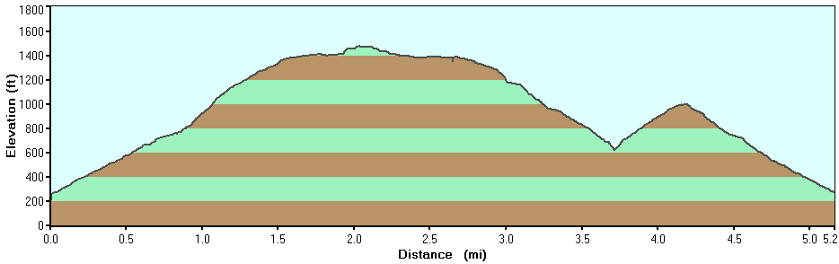
The marathon course was two loops of the half marathon course. It started on Rodeo Beach and climbed up the Marin Headlands looping back around. The elevation profile included a 4,840 ft gain with several steep inclines, including one 800 ft gain within the first 1.5 miles, and a second 600 ft gain over another 1.5 miles. The course consisted of primarily single track or fire road terrain with only 15% being asphalt. Needless to say, this was a tough course. Below is the elevation chart for the half marathon. We ran this twice!

The easiest way to break it down is by aid stations. There were three aid stations. Mile 4.1 (repeated at Mile 17.2), Mile 8.6 (repeated at 21.7), and mile 13.1
The Plan: To finish. Given that I was having some potential foot issues, I had no time goal in mind. Originally I had a rough estimate of 7:00, but I didn’t want to push anything. Lately, I’ve been running straight or at 5:00/1:30 intervals. I felt that I should be more conservative so I set Runkeeper to a 2:00/1:00 ratio, knowing that it will be difficult to maintain given the terrain. When possible, I would try to stick with that, otherwise, it was dependent upon the course.
Start to First Station: The start was slow. The course was crowded with both marathon and half marathon runners starting at the same time. Immediately, the elevation began to climb and everyone except the diehards were walking/hiking up the inclines. Around the mile mark, probably more like 0.8 miles, the trail was so steep, we were climbing stairs with handrails. The fog was thick, and soon, we were unable to see how far we’d climbed. This gave it an eerie feeling of isolation, but I couldn’t think about that with all the HMers surrounding me. Around mile 1.5 the trail topped out and there were some rolling hills on single track terrain until the decent to the first aid station. 

I was surprised at how well the aid station was manned and stocked. There were a ton of snacks to be had, including banana, orange, Oreos, M&Ms, PBJ, trail mix, boiled potatoes, salt tablets, and more. Everyone was friendly and very helpful. This station was situated in a valley with horse stables and a reminded me of an outpost in the vast nothingness of the fog.

Between Aid Stations: After fueling up for a couple of minutes, I began the slow and steady trek up the next major climb, roughly 1.5 miles of fire road without a break. I hooked up with an older gentleman and we chatted about running and work. I stuck with him for most of the climb and the chatting kept my mind off of the unrelenting incline. We kept it at a walk, as did nearly everyone else. The trail runners creed is “walk the hills, and power down the other side” or something like that. Eventually we crested and found ourselves along single track again with moderate winds coming from below. Again, the eeriness of the fog made it feel like we were on top of the world. At one point we hit some thick forest that reminded me somewhat of the cloud forests of Costa Rica. It was only a short portion but very cool. More single track along the side of the mountains with no room for error. One false move and you would plummet several hundred feet into the nothingness. For the most part, this stretch was relatively flat, with several rolling hills. Eventually we crossed a paved road and up to the second aid station, adjacent to a roundabout.


Again, this station was well stocked and manned, just as the first. I had been texting Jen my estimated progress and came to this station much soon than expected. As I understand it, there was some hurried, and probably cursing movements on my families side to try and see me at the half point. I fueled up again and took off.
Roundabout Station to Half Point: This section was relatively easy compared to the previous two. There was only one steep climb, but it was short and after a lengthy downward stretch. Vegetation throughout this portion was thick and many times we were brushing up against something. At one point, I was letting some faster runners by when I grazed a stinging nettle, or similar plant. I didn’t get it bad, but there was some slight stinging along my right knee for about 10 minutes. Around mile 11.5 we were at the top of the last hill in the loop, and this is where I had the best views of the race. I was able to see the Golden Gate Bridge for the first time since the race started and it was well worth the effort. After this, it was a stead down hill then about a 1/4 mile flat stretch along the road to the half way point (finish for the HMers). I started hearing some yelling and there they were, my family. Jen, Paige, Connor, Mom, Dad, Annie (sister), and Lily (niece), hollering and cheering me on. They were probably one of the few true spectators of the race, as most people there were participants. A few high fives and a short walk with them, then I headed to the half point aid station. Yet again, a well done aid station.


Second Loop Start to First Aid Station: I’d completed the loop and knew exactly what laid before me. Daunting as it was, I headed out, tired but feeling good about it. This time around, there were no HMers, and few-to-none marathoners or 50Kers near me. The trek of the first incline was lonely and exhausting. The few people near me moved on ahead as I stopped for several photo/rest breaks. By the mid-climb point, I was alone other than the occasional hiker. Soon after reaching the summit, I was a couple marathoners I’d talked with earlier. I was determined to catch them by the aid station. I did not want to tackle the second long climb alone. The long climb took much longer than the first time, but I was making up ground and caught them just before the aid station.

Station to Station (Take Two): I headed out with several other runners and we talked and struggled up the climb. This time around, walking the hill just didn’t cut it, every 5 minutes or so, I needed to stop for a short breather. Then I’d catch the other runners until the next one. The trail slowly turned to the right with the hint of finishing, only to be handed more hill. Eventually we hit the top and back to running.
I ended up loosing the other runners and did see anyone for about 3 miles. This was the most trying part of the race for me. Even though the fog had lifted somewhat, this part was thick with fog and a roaring wind coming from below. The isolation and fog made me feel very alone. Exhausted from the previous 20 miles, I was struggling to maintain the runs. I tried run/walks, but had to take some mini breaks to catch my breath, my energy was low, even with refueling heavily. Eventually I came to the round about aid station. Civilization at last! If felt like hours had past since I’d seen anyone. After a few minutes of downing some sports drink and sugary goodies, I was feeling revived. “Only 4.5 miles left to go. I can do this!” Plus, a group of other runners were taking off about the same time. I wouldn’t feel so alone now.

Roundabout Station to Finish: I kept with my 2/1 ratio throughout this part of the race, except that last hill. I followed up a couple that were running there first marathon together. The guy signed them up not knowing it was a trail run. By the looks of the girl, he was in for more pain when they got home. Finally the last decent, no more hills to climb! Even though I was truly exhausted, I kept trucking along and eventually hit the last stretch. Nice and flat! I was tapped out, holding up the run was tough, but soon I was hitting the final turn and about 50 feet to the finish. I pushed it with all I had to sprint the last bit. I’m sure it didn’t look anything like a sprint, but it sure felt like it. Finally! I crossed the finish line with Jen and Connor cheering me on (The rest of the family had headed to Muir Woods and weren’t back in time for the finish). Such relief to be done. I down some watermelon and other goodies and was surprised to find one of my favorite things, coconut water, waiting for me, along with a hot cup of soup. YUM!


After some rest, I hit the shower, a cold beach shower and we headed out to meet the rest of the family, have dinner, and hit the airport for a redeye home, which was delayed, ugg! I slept nearly the entire 5 hour flight and we got home around 8am, where I promptly slept until 3:45pm.
All in all, a great vacation with a great race to finish it up!
Oh, and about that foot pain, I had ABSOLUTELY no issues the entire run. in fact, the only thing that did bother me, other than fatigue, was a slight twinge in my right hamstring, but it never surfaced.
48 hours after finishing and I’m still sore, but in that good way. Nothing that shouldn’t be cleared up within a day or two.
Now where’s that 50K I need to sign up for?